Thursday, July 8, 2010
Wednesday, July 7, 2010
Oil Spill - The Curse of the Gulf Stream
2010-7-7 7.49
Now why would somebody on a little island on the west coast of Africa think much about an oil spill roughly 10.000 Kilometers away?Glad you asked.
If I learned anything from my visits to Disney World it is a sentence from the Lion King show at the Land in Epcot:
We are all connected in the big circle of life.
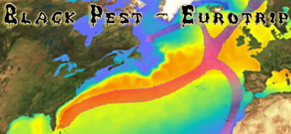
In this case sadly by a beneficial current known as the Gulf Stream.

The red arrows are the "Gulf Stream" (not exactly, the current changes names as it splits and moved through different regions, but you get a general idea).
I put an overlay (darker rectangle) over the map to show the behavior of the surface movement. This is a picture from the path of drifter buoys.
If you want to know more about the movement of the drifter buoys and see in which time they move how far and in what direction, look here and if you click on the circles and if you can see Link to trajectory shaded by time then tou find info like the one below.
(you might need to move the slider towards minus if you do not see anything)

Now if you think that guy is nuts, the gulf stream is far away from the oil spill, you are sadly mistaken at least on one count.
Some people at the university of Miami had the same idea, and this is what they came up with.

Florida Keys beachcombers in the next eight to 10 days may find tar oozing between their toes.
Federal officials said Tuesday that a tendril of oil from the massive and growing Deepwater Horizon slick appears to have latched onto the Gulf Loop. The statement by officials of the National Atmospheric and Oceanic Administration confirmed academics' conclusions and provided further signs that currents will carry oil through the Keys and up the state's southeastern coast toward Palm Beach County.
more here.
 In the picture above there is a loop current mentioned, now what is that?
Let´s go to the Gulf Stream Tutorial and get an idea.
You will find The Path of the Gulf Stream and it shows what the Loop Current is, it is just a bend in the Gulf Stream.
Now it looks like you folks north of the Orlando area are out of harms way...
Think again and lets do some more research, shall we?
Here is a word the people on the east cost of America will learn to hate:
The path of the Gulf Stream is constantly changing downstream of Cape Hatteras. The Stream often develops wave-like patterns called meanders.
Go to here to get an idea why if the oil reaches the Gulf Stream will mess up the east coast too.
You also might want to read more about Gulf Stream currents from CIMAS


The oil from the BP leak could reach far beyond the Gulf of Mexico, according to a new computer model released Thursday that shows currents could carry some of the slick up the Atlantic coast.
The creators of the model, the National Center for Atmospheric Research, said oil could reach the open Atlantic Ocean as early as this summer.
for more in dept info go directly to the UCAR website
Oil has been pouring into the Gulf of Mexico since April 20 from a blown-out undersea well, the result of an explosion and fire on an oil rig. The spill is located in a relatively stagnant area of the Gulf, and the oil so far has remained relatively confined near the Louisiana and Alabama coastlines, although there have been reports of small amounts in the Loop Current.
The model simulations show that a liquid released in the surface ocean at the spill site is likely to slowly spread as it is mixed by the ocean currents until it is entrained in the Loop Current. At that point, speeds pick up to about 40 miles per day, and when the liquid enters the Atlantic's Gulf Stream it can travel at speeds up to about 100 miles per day, or 3,000 miles per month.
According to researchers, oil could threaten East Coast beaches by early July, but they cautioned the models were not a forecast.
“Very direct, rapid linkages exist between the location of this spill and our beaches in North Carolina,” Rader said.
Rader said the state will eventually see tar balls on North Carolina beaches.
“Birds and fish and sea turtles and a wide array of important marine creature are at risk,” he said.
Seafood along parts of the outer banks could contain some of the toxicity.
Should the oil arrive, the state Division of Public Health has created warnings for swimmers, boaters and fishermen. They include avoiding oily waters and contaminated seafood.
Rader said the effects of the oil could be around North Carolina beaches for a while. He said the longer the oil leaks in the gulf, the longer it will trail along the Carolina coast.
“The amount of toxic material loose in the Gulf and moving toward us in the Atlantic is without precedent,” he said.
After affecting the East Coast, the oil could then head by Bermuda on its way to Europe.
Martin Visbeck, a research team member with the University of Kiel in Germany, says it is unlikely any oil reaching Europe would be thick enough to be harmful.
Oil enters Loop Current


The university of Hawaii made a 0ne Year what if scenario:
The longterm fate of the oil spill in the Atlantic
Monday, June 7, 2010
Eddy to the rescue from the Florida Keys to the east coast
2010-6-7 21.21
So if on the 17th of May already oil entered the Loop Current, why isn´t it in the Keys or Miami 20 days later?
Because of eddy.
Every 6 - 11 months, the top bulge of the Loop Current cuts off, forming a 250-mile diameter circular eddy in the middle of the Gulf of Mexico. This clockwise-spinning eddy is filled with warm water from the Loop Current, and is called a Loop Current Eddy. The main body of the Loop Current then takes a fairly direct eastward path from the Yucatan Channel to the Florida Keys.

By May 27, this loop had separated, and new oil moving southwards from the spill will now be trapped in the clockwise rotating Loop Current Eddy that is cut off from the Loop Current.

See animation here.
During the first 1 - 2 months that a Loop Current Eddy forms, it is common for the eddy to exchange substantial amounts of water with the Loop Current, and in some cases get re-absorbed into the Loop Current.
It remains to be seen if the deep water currents have followed suit, and a stable Loop Current Eddy cannot exist until the deep water currents also cut off into a clockwise-rotating ring of water at depth.
Read the complete article at Dr. Jeff Masters' WunderBlog
The cycle of forming an eddy from the loop current. Read more about that here.


I had the fear of the oil plumes hitchhiking from the loop current into the gulf stream, but with this data now, this fear is luckily short lived.
The shallowest oil plume so far detected is at about 2,300 feet (700 m), while the deepest was near the sea floor at about 4,200 feet (1,300 m).
So with this information, I can see the whole east coast from the Florida Keys up to North Carolina cheer:
GO EDDY GO!
GO EDDY GO!

...
I feel very sorry for you guys on the Gulf of Mexico, because Katrina and Rita got their supercharge from a similar eddy what separated in July. You might be in for much more trouble.
Jonnie will keep you posted what´s going on in that region.
... and the last name of Eddy is "Franklin"
Deepwater Horizon - The amount of oil spilled
2010-6-7 0.2
This does not look so bad, does it? I mean compared to the Ixtoc disaster what did not do too much damage in the Gulf of Mexico (at least according to Wikipedia). But why can nobody go check so the world get´s a better idea what to deal with?
Wikipedia on the Deepwater Horizon oil spill states:
The exact spill flow rate is uncertain – in part because BP has refused to allow independent scientists to perform accurate measurements – and is a matter of ongoing debate.
"BP has resisted entreaties from scientists that they be allowed to use sophisticated instruments at the ocean floor that would give a far more accurate picture of how much oil is really gushing from the well.
“The answer is no to that,” a BP spokesman, Tom Mueller, said on Saturday. “We’re not going to take any extra efforts now to calculate flow there at this point. It’s not relevant to the response effort, and it might even detract from the response effort.” (NYT)"
So what do we know:
BP initially estimated that the wellhead was leaking 1,000 barrels (42,000 US gallons; 160,000 litres) a day.
On April 28, the National Oceanic and Atmospheric Administration estimated that the leak was likely 5,000 barrels (210,000 US gallons; 790,000 litres) a day.
Timothy Crone, an associate research scientist at the Lamont-Doherty Earth Observatory, estimated at least 50,000 barrels (2,100,000 US gallons; 7,900,000 litres) a day.
Eugene Chaing, a professor of astrophysics at the University of California, Berkeley, estimated the leak to be 20,000–100,000 barrels (840,000–4,200,000 US gallons; 3,200,000–16,000,000 litres) a day.
Steven Wereley, an associate professor at Purdue University used particle image velocimetry to initially arrive at a rate of 70,000 barrels (2,900,000 US gallons; 11,000,000 litres) per day, with a margin of error of 20 percent.
Wereley concluded the leak was likely considerably more than he initially estimated, after viewing the released footage of the leak, stating before Congress that the leak was likely 95,000 barrels (4,000,000 US gallons; 15,100,000 litres) a day.
On May 27, 2010 the government increased its official estimate to 12,000–19,000 barrels (500,000–800,000 US gallons; 1,900,000–3,000,000 litres) a day.
According to Ira Leifer, a member of the Flow Rate Technical Group, the group was only provided an approximately seven minute time segment of low-quality video selected by BP, which showed a lot of variability from very low to very high flows.
PBS NewsHour:
The New York Times reported that BP told members of Congress the rate could be much, much higher:
In a closed-door briefing for members of Congress, a senior BP executive conceded Tuesday that the ruptured oil well could conceivably spill as much as 60,000 barrels a day of oil, more than 10 times the estimate of the current flow.
A barrel of crude oil contains roughly 42 gallons. In a follow-up story, the Times talked to a BP spokesman for more on the estimate:
"The rate could go up to that," Mr. Suttles of BP said, when asked to verify a report in The Times. "It's not the situation we have at this moment, but it's not impossible."
That all looks a bit more than (dead) fishy to me, pardon the pun.
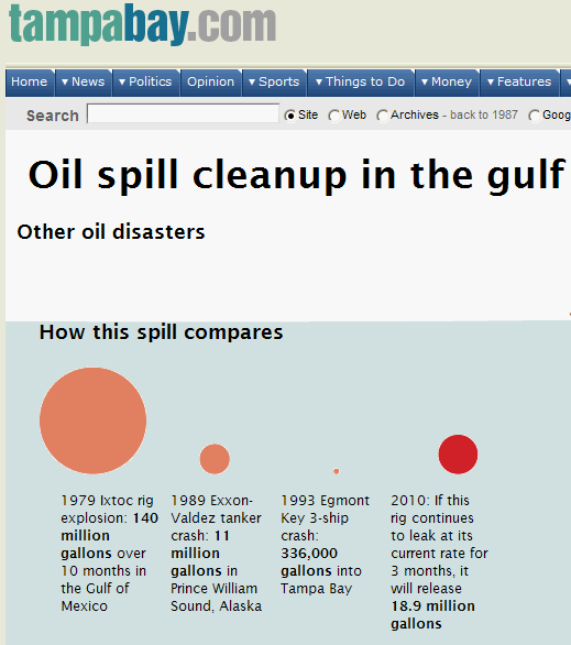
If we now compare the Wiki entries from both spills so far:
Ixtoc I - Volume 3,000,000 barrels; 480,000,000 litres total - Area 2,800 km2; 1,100 sq mi - Coastline impacted 261 km (162 mi)
Deepwater Horizon - up to 100,000 barrels; 4,200,000 US gallons; 16,000,000 litres per day - Area 6,500 to 24,000 km2; 2,500 to 9,100 sq mi
2010-6-6
46 Days since the spill.
46 times up to 100,000 barrels makes up to 4,600,000 barrels spilled so far.
4,200,000 US gallons times 46 days makes up to 193 million US gallons so far.
Tampabay.com I think you have a slight error in your calculation. It looks we already surpassed the Ixtoc I volume.
Answeers.com has an interesting graphic and states correctly:
Note: the extent of the Deepwater Horizon oil spill has not been well determined as of this writing.
But their comparison of the biggest oil spills is quite interesting

So according to to low estimates it is still the smallest from the big spills, but according to the scientists it already kicked the Ixtoc I from the third spot.
Now some estimates are made on the amount of spread seen on satellite images. What they can not take into account is:
On May 15, researchers from the University of Southern Mississippi, aboard the research vessel RV Pelican, identified oil plumes in the deep waters of the Gulf of Mexico, including one as large as 10 miles (16 km) long, 3 miles (4.8 km) wide and 300 feet (91 m) thick in spots.
6.7 (cubic kilometers) = 42.141.732.200 oil barrel if the plume was rectangular.
So the amount is much smaller but there are more than one plume and they had time to grow.
The shallowest oil plume the group detected was at about 2,300 feet (700 m), while the deepest was near the seafloor at about 4,200 feet (1,300 m). Other researchers from the University of Georgia have found that the oil may occupy multiple layers. Wikipedia
Scientists are finding enormous oil plumes in the deep waters of the Gulf of Mexico, including one as large as 10 miles long, 3 miles wide and 300 feet thick in spots. The discovery is fresh evidence that the leak from the broken undersea well could be substantially worse than estimates that the government and BP have given.
The plumes were discovered by scientists from several universities working aboard the research vessel Pelican, which sailed from Cocodrie, La., on May 3 and has gathered extensive samples and information about the disaster in the gulf.
more at the New York Times
So 13 days after the accident there were already enormous oil plumes in the deep waters why don´t we hear more about that?
What if these plumes find the way into the Gulf Stream and dispersing the oil slowly up the coast line?

This does not look so bad, does it? I mean compared to the Ixtoc disaster what did not do too much damage in the Gulf of Mexico (at least according to Wikipedia). But why can nobody go check so the world get´s a better idea what to deal with?
Wikipedia on the Deepwater Horizon oil spill states:
The exact spill flow rate is uncertain – in part because BP has refused to allow independent scientists to perform accurate measurements – and is a matter of ongoing debate.
"BP has resisted entreaties from scientists that they be allowed to use sophisticated instruments at the ocean floor that would give a far more accurate picture of how much oil is really gushing from the well.
“The answer is no to that,” a BP spokesman, Tom Mueller, said on Saturday. “We’re not going to take any extra efforts now to calculate flow there at this point. It’s not relevant to the response effort, and it might even detract from the response effort.” (NYT)"
So what do we know:
BP initially estimated that the wellhead was leaking 1,000 barrels (42,000 US gallons; 160,000 litres) a day.
On April 28, the National Oceanic and Atmospheric Administration estimated that the leak was likely 5,000 barrels (210,000 US gallons; 790,000 litres) a day.
Timothy Crone, an associate research scientist at the Lamont-Doherty Earth Observatory, estimated at least 50,000 barrels (2,100,000 US gallons; 7,900,000 litres) a day.
Eugene Chaing, a professor of astrophysics at the University of California, Berkeley, estimated the leak to be 20,000–100,000 barrels (840,000–4,200,000 US gallons; 3,200,000–16,000,000 litres) a day.
Steven Wereley, an associate professor at Purdue University used particle image velocimetry to initially arrive at a rate of 70,000 barrels (2,900,000 US gallons; 11,000,000 litres) per day, with a margin of error of 20 percent.
Wereley concluded the leak was likely considerably more than he initially estimated, after viewing the released footage of the leak, stating before Congress that the leak was likely 95,000 barrels (4,000,000 US gallons; 15,100,000 litres) a day.
On May 27, 2010 the government increased its official estimate to 12,000–19,000 barrels (500,000–800,000 US gallons; 1,900,000–3,000,000 litres) a day.
According to Ira Leifer, a member of the Flow Rate Technical Group, the group was only provided an approximately seven minute time segment of low-quality video selected by BP, which showed a lot of variability from very low to very high flows.
PBS NewsHour:
The New York Times reported that BP told members of Congress the rate could be much, much higher:
In a closed-door briefing for members of Congress, a senior BP executive conceded Tuesday that the ruptured oil well could conceivably spill as much as 60,000 barrels a day of oil, more than 10 times the estimate of the current flow.
A barrel of crude oil contains roughly 42 gallons. In a follow-up story, the Times talked to a BP spokesman for more on the estimate:
"The rate could go up to that," Mr. Suttles of BP said, when asked to verify a report in The Times. "It's not the situation we have at this moment, but it's not impossible."
That all looks a bit more than (dead) fishy to me, pardon the pun.
If we now compare the Wiki entries from both spills so far:
Ixtoc I - Volume 3,000,000 barrels; 480,000,000 litres total - Area 2,800 km2; 1,100 sq mi - Coastline impacted 261 km (162 mi)
Deepwater Horizon - up to 100,000 barrels; 4,200,000 US gallons; 16,000,000 litres per day - Area 6,500 to 24,000 km2; 2,500 to 9,100 sq mi
2010-6-6
46 Days since the spill.
46 times up to 100,000 barrels makes up to 4,600,000 barrels spilled so far.
4,200,000 US gallons times 46 days makes up to 193 million US gallons so far.
Tampabay.com I think you have a slight error in your calculation. It looks we already surpassed the Ixtoc I volume.
Answeers.com has an interesting graphic and states correctly:
Note: the extent of the Deepwater Horizon oil spill has not been well determined as of this writing.
But their comparison of the biggest oil spills is quite interesting

So according to to low estimates it is still the smallest from the big spills, but according to the scientists it already kicked the Ixtoc I from the third spot.
Now some estimates are made on the amount of spread seen on satellite images. What they can not take into account is:
On May 15, researchers from the University of Southern Mississippi, aboard the research vessel RV Pelican, identified oil plumes in the deep waters of the Gulf of Mexico, including one as large as 10 miles (16 km) long, 3 miles (4.8 km) wide and 300 feet (91 m) thick in spots.
6.7 (cubic kilometers) = 42.141.732.200 oil barrel if the plume was rectangular.
So the amount is much smaller but there are more than one plume and they had time to grow.
The shallowest oil plume the group detected was at about 2,300 feet (700 m), while the deepest was near the seafloor at about 4,200 feet (1,300 m). Other researchers from the University of Georgia have found that the oil may occupy multiple layers. Wikipedia
Scientists are finding enormous oil plumes in the deep waters of the Gulf of Mexico, including one as large as 10 miles long, 3 miles wide and 300 feet thick in spots. The discovery is fresh evidence that the leak from the broken undersea well could be substantially worse than estimates that the government and BP have given.
The plumes were discovered by scientists from several universities working aboard the research vessel Pelican, which sailed from Cocodrie, La., on May 3 and has gathered extensive samples and information about the disaster in the gulf.
more at the New York Times
So 13 days after the accident there were already enormous oil plumes in the deep waters why don´t we hear more about that?
What if these plumes find the way into the Gulf Stream and dispersing the oil slowly up the coast line?
Sunday, June 6, 2010
Link Collection
2010-6-6 14.44
Check out this interactive oil spill projection map with lots of information layers
NOAA latest news
Mapping the Slick: Oil in Loop Current Threatens Florida Keys and Delicate Coral Reefs. If you think that this can be over in a few months, you are sadly mistaken. This isn't going away (Valdez oil -- from 1989 -- is still in Alaskan waters)
CSM: Alaska beaches still have oil from 1989 spill
Discover: 21 Years After Spill, Exxon Valdez Oil Is *Still* Stuck in Alaska’s Beaches
CBCNews: Exxon Valdez oil still found in Alaskan ducks
 THIS IS MUCH MUCH WORSE.
Cap collects some Gulf oil; crude washes into Fla.
Now, an estimated 500,000 to 1 million gallons of crude is believed to be leaking daily.
Waterfront Homes Auctioned At Up To 75 Percent Off. Do these people thinking better now than never?
Ocean Motion Wind Driven Surface Currents: Gyres
In Germany same thoughts as mine surface.
Visualizing the BP Oil Spill Disaster
Ixtoc I oil spill @ wikipedia ...also drilled two relief wells into the main well to lower the pressure of the blowout, however the oil continued to flow for three months following the completion of the first relief well.
PBS NewsHour oil spill timeline
MPR News
Subscribe to:
Posts (Atom)