Thursday, July 8, 2010
Wednesday, July 7, 2010
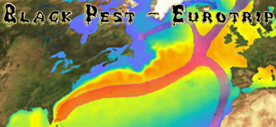
Oil Spill - The Curse of the Gulf Stream
2010-7-7 7.49
Now why would somebody on a little island on the west coast of Africa think much about an oil spill roughly 10.000 Kilometers away?Glad you asked.
If I learned anything from my visits to Disney World it is a sentence from the Lion King show at the Land in Epcot:
We are all connected in the big circle of life.
In this case sadly by a beneficial current known as the Gulf Stream.

The red arrows are the "Gulf Stream" (not exactly, the current changes names as it splits and moved through different regions, but you get a general idea).
I put an overlay (darker rectangle) over the map to show the behavior of the surface movement. This is a picture from the path of drifter buoys.
If you want to know more about the movement of the drifter buoys and see in which time they move how far and in what direction, look here and if you click on the circles and if you can see Link to trajectory shaded by time then tou find info like the one below.
(you might need to move the slider towards minus if you do not see anything)

Now if you think that guy is nuts, the gulf stream is far away from the oil spill, you are sadly mistaken at least on one count.
Some people at the university of Miami had the same idea, and this is what they came up with.

Florida Keys beachcombers in the next eight to 10 days may find tar oozing between their toes.
Federal officials said Tuesday that a tendril of oil from the massive and growing Deepwater Horizon slick appears to have latched onto the Gulf Loop. The statement by officials of the National Atmospheric and Oceanic Administration confirmed academics' conclusions and provided further signs that currents will carry oil through the Keys and up the state's southeastern coast toward Palm Beach County.
more here.
 In the picture above there is a loop current mentioned, now what is that?
Let´s go to the Gulf Stream Tutorial and get an idea.
You will find The Path of the Gulf Stream and it shows what the Loop Current is, it is just a bend in the Gulf Stream.
Now it looks like you folks north of the Orlando area are out of harms way...
Think again and lets do some more research, shall we?
Here is a word the people on the east cost of America will learn to hate:
The path of the Gulf Stream is constantly changing downstream of Cape Hatteras. The Stream often develops wave-like patterns called meanders.
Go to here to get an idea why if the oil reaches the Gulf Stream will mess up the east coast too.
You also might want to read more about Gulf Stream currents from CIMAS


The oil from the BP leak could reach far beyond the Gulf of Mexico, according to a new computer model released Thursday that shows currents could carry some of the slick up the Atlantic coast.
The creators of the model, the National Center for Atmospheric Research, said oil could reach the open Atlantic Ocean as early as this summer.
for more in dept info go directly to the UCAR website
Oil has been pouring into the Gulf of Mexico since April 20 from a blown-out undersea well, the result of an explosion and fire on an oil rig. The spill is located in a relatively stagnant area of the Gulf, and the oil so far has remained relatively confined near the Louisiana and Alabama coastlines, although there have been reports of small amounts in the Loop Current.
The model simulations show that a liquid released in the surface ocean at the spill site is likely to slowly spread as it is mixed by the ocean currents until it is entrained in the Loop Current. At that point, speeds pick up to about 40 miles per day, and when the liquid enters the Atlantic's Gulf Stream it can travel at speeds up to about 100 miles per day, or 3,000 miles per month.
According to researchers, oil could threaten East Coast beaches by early July, but they cautioned the models were not a forecast.
“Very direct, rapid linkages exist between the location of this spill and our beaches in North Carolina,” Rader said.
Rader said the state will eventually see tar balls on North Carolina beaches.
“Birds and fish and sea turtles and a wide array of important marine creature are at risk,” he said.
Seafood along parts of the outer banks could contain some of the toxicity.
Should the oil arrive, the state Division of Public Health has created warnings for swimmers, boaters and fishermen. They include avoiding oily waters and contaminated seafood.
Rader said the effects of the oil could be around North Carolina beaches for a while. He said the longer the oil leaks in the gulf, the longer it will trail along the Carolina coast.
“The amount of toxic material loose in the Gulf and moving toward us in the Atlantic is without precedent,” he said.
After affecting the East Coast, the oil could then head by Bermuda on its way to Europe.
Martin Visbeck, a research team member with the University of Kiel in Germany, says it is unlikely any oil reaching Europe would be thick enough to be harmful.
Oil enters Loop Current


The university of Hawaii made a 0ne Year what if scenario:
The longterm fate of the oil spill in the Atlantic
Subscribe to:
Posts (Atom)